본문
위・아래
삭제
복제
복제전송
 수정
링크걸기
링크해제
수정
링크걸기
링크해제
수정
링크걸기
링크해제
위・아래
삭제
복제
복제전송
 수정
링크걸기
링크해제
수정
링크걸기
링크해제
수정
링크걸기
링크해제
위・아래
삭제
복제
복제전송
텍스트기본스타일
 행남 코스
행남 코스
-
-
-
- 현재창
- 새창
-
-
-
-
-
선색
- 실선
- 점선
- all
- top
- right
- bottom
- left
- 0px
- 1px
- 2px
- 3px
- 4px
- 5px
-
선색
-
- all
- top
- right
- bottom
- left
- 0px
- 5px
- 10px
- 15px
- 20px
- 25px
- 30px
- 35px
- 40px
-
- all
- top
- bottom
- 0px
- 5px
- 10px
- 15px
- 20px
- 25px
- 30px
- 35px
- 40px
-
- 4px
- 8px
- 10px
- 12px
- 16px
- 20px
- 30px
-
- 1.3em
- 1.5em
- 2em
- 2.2em
- 2.5em
- 3em
-


위・아래
삭제
복제
복제전송
텍스트기본스타일
-
-
-
- 현재창
- 새창
-
-
-
-
-
선색
- 실선
- 점선
- all
- top
- right
- bottom
- left
- 0px
- 1px
- 2px
- 3px
- 4px
- 5px
-
선색
-
- all
- top
- right
- bottom
- left
- 0px
- 5px
- 10px
- 15px
- 20px
- 25px
- 30px
- 35px
- 40px
-
- all
- top
- bottom
- 0px
- 5px
- 10px
- 15px
- 20px
- 25px
- 30px
- 35px
- 40px
-
- 4px
- 8px
- 10px
- 12px
- 16px
- 20px
- 30px
-
- 1.3em
- 1.5em
- 2em
- 2.2em
- 2.5em
- 3em
-
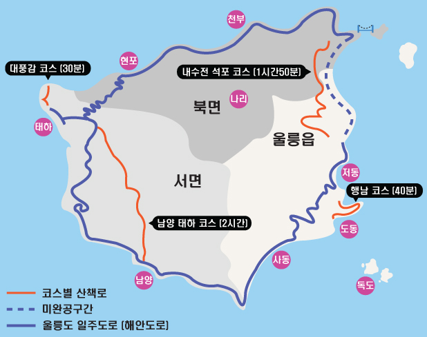
도동항 좌측해안을 따라 개설된 산책로로 KBS 1박2일 촬영 후부터 큰 인기를 끌고 있는 총 길이 2.9km에 40분 정도 소요되는 코스입니다.
위・아래
삭제
복제
복제전송
텍스트기본스타일
남양태하 코스
-
-
-
- 현재창
- 새창
-
-
-
-
-
선색
- 실선
- 점선
- all
- top
- right
- bottom
- left
- 0px
- 1px
- 2px
- 3px
- 4px
- 5px
-
선색
-
- all
- top
- right
- bottom
- left
- 0px
- 5px
- 10px
- 15px
- 20px
- 25px
- 30px
- 35px
- 40px
-
- all
- top
- bottom
- 0px
- 5px
- 10px
- 15px
- 20px
- 25px
- 30px
- 35px
- 40px
-
- 4px
- 8px
- 10px
- 12px
- 16px
- 20px
- 30px
-
- 1.3em
- 1.5em
- 2em
- 2.2em
- 2.5em
- 3em
-
위・아래
삭제
복제
복제전송
텍스트기본스타일
-
-
-
- 현재창
- 새창
-
-
-
-
-
선색
- 실선
- 점선
- all
- top
- right
- bottom
- left
- 0px
- 1px
- 2px
- 3px
- 4px
- 5px
-
선색
-
- all
- top
- right
- bottom
- left
- 0px
- 5px
- 10px
- 15px
- 20px
- 25px
- 30px
- 35px
- 40px
-
- all
- top
- bottom
- 0px
- 5px
- 10px
- 15px
- 20px
- 25px
- 30px
- 35px
- 40px
-
- 4px
- 8px
- 10px
- 12px
- 16px
- 20px
- 30px
-
- 1.3em
- 1.5em
- 2em
- 2.2em
- 2.5em
- 3em
-
높이 462m의 태하령을 지나는 산책로로 울릉도 일주도로가 개통되기 전 유일한 교통로였고 울창한 삼림속에 완만한 경사를 걷게 되는 총 길이 6km에 2시간 정도 소요되는 코스입니다.
위・아래
삭제
복제
복제전송
텍스트기본스타일
대풍감 코스
-
-
-
- 현재창
- 새창
-
-
-
-
-
선색
- 실선
- 점선
- all
- top
- right
- bottom
- left
- 0px
- 1px
- 2px
- 3px
- 4px
- 5px
-
선색
-
- all
- top
- right
- bottom
- left
- 0px
- 5px
- 10px
- 15px
- 20px
- 25px
- 30px
- 35px
- 40px
-
- all
- top
- bottom
- 0px
- 5px
- 10px
- 15px
- 20px
- 25px
- 30px
- 35px
- 40px
-
- 4px
- 8px
- 10px
- 12px
- 16px
- 20px
- 30px
-
- 1.3em
- 1.5em
- 2em
- 2.2em
- 2.5em
- 3em
-
위・아래
삭제
복제
복제전송
텍스트기본스타일
-
-
-
- 현재창
- 새창
-
-
-
-
-
선색
- 실선
- 점선
- all
- top
- right
- bottom
- left
- 0px
- 1px
- 2px
- 3px
- 4px
- 5px
-
선색
-
- all
- top
- right
- bottom
- left
- 0px
- 5px
- 10px
- 15px
- 20px
- 25px
- 30px
- 35px
- 40px
-
- all
- top
- bottom
- 0px
- 5px
- 10px
- 15px
- 20px
- 25px
- 30px
- 35px
- 40px
-
- 4px
- 8px
- 10px
- 12px
- 16px
- 20px
- 30px
-
- 1.3em
- 1.5em
- 2em
- 2.2em
- 2.5em
- 3em
-
천연기념물 제 29호로 지정되어 있는 대풍감 향나무 자생지를 한눈에 내려다 볼 수 있는 산책로로 대한민국 10대 비경 중 한 곳이 태하등대 전망대까지 총 길이 1.5km에 30분 정도 소요되는 코스입니다.
위・아래
삭제
복제
복제전송
텍스트기본스타일
내수전석포 코스
-
-
-
- 현재창
- 새창
-
-
-
-
-
선색
- 실선
- 점선
- all
- top
- right
- bottom
- left
- 0px
- 1px
- 2px
- 3px
- 4px
- 5px
-
선색
-
- all
- top
- right
- bottom
- left
- 0px
- 5px
- 10px
- 15px
- 20px
- 25px
- 30px
- 35px
- 40px
-
- all
- top
- bottom
- 0px
- 5px
- 10px
- 15px
- 20px
- 25px
- 30px
- 35px
- 40px
-
- 4px
- 8px
- 10px
- 12px
- 16px
- 20px
- 30px
-
- 1.3em
- 1.5em
- 2em
- 2.2em
- 2.5em
- 3em
-
위・아래
삭제
복제
복제전송
텍스트기본스타일
-
-
-
- 현재창
- 새창
-
-
-
-
-
선색
- 실선
- 점선
- all
- top
- right
- bottom
- left
- 0px
- 1px
- 2px
- 3px
- 4px
- 5px
-
선색
-
- all
- top
- right
- bottom
- left
- 0px
- 5px
- 10px
- 15px
- 20px
- 25px
- 30px
- 35px
- 40px
-
- all
- top
- bottom
- 0px
- 5px
- 10px
- 15px
- 20px
- 25px
- 30px
- 35px
- 40px
-
- 4px
- 8px
- 10px
- 12px
- 16px
- 20px
- 30px
-
- 1.3em
- 1.5em
- 2em
- 2.2em
- 2.5em
- 3em
-
서서히 내리막을 걷다가 나리분지 용천수가 흐르는 계곡을 기점으로 완만하게 오르내리는 산책로로 울창한 삼림과 마치 눈 앞에서 보는 듯하게 가깝게 펼쳐지는 죽도를 볼 수 있어 인기가 높은 총 길이 6.2km에 약 1시간 50분 정도 소요되는 코스입니다.